Nice Indians!
Maarten Vanden Eynde
Nice Indians, 2007
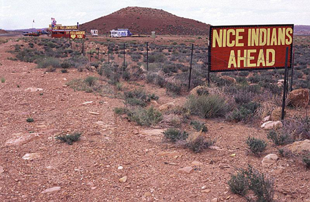
Most of the ‘Native Americans’ are situated in the state of California, 627.562 to be precise. More than twice as much as in number two, Arizona. It’s the last refuge corner of the United States, the bottleneck towards South America. While driving through the Grand Canyon you are confronted with many native Indian shops next to the road. In the most desolate environment they sell original Indian jewelry and other souvenirs to passing tourists. They usually make themselves noticed by putting hand painted signs NICE INDIANS AHEAD fifty meters before the little store, followed by NICE INDIANS when you pass the store and about another fifty meters further they remind you or call you back by saying NICE INDIANS BEHIND! TURN AROUND…
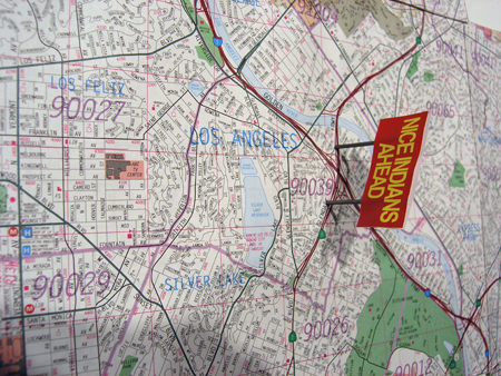
In a way, this sums up the whole history of the United States, starting from Columbus to the present day. From the day the Europeans went to America (NICE INDIANS AHEAD), followed by the period in which ground was traded for pearl necklaces and new cities were build (NICE INDIANS), up to the present day where the tourist industry is profiting from the ancient wild west image and mass producing genuine Indian props (NICE INDIANS BEHIND). I want to copy/paste this time line into the contemporary topography of LA by replacing the signs into the city of Los Angeles.
Location:
Interstate 5 (abbreviated I-5) is the westernmost interstate highway in the continental United States. Its odd number indicates that it is a north-south highway. Its southern terminus is at the international border between the United States and Mexico in the San Diego community of San Ysidro, California. Its northern terminus is at the international border between the United States and Canada at the Peace Arch in Blaine, Washington. An extensive section of this highway (over 600 miles or 965 km), from approximately Stockton, California to Vancouver, Washington, follows very closely the track of the Siskiyou Trail. The Siskiyou Trail was based on an ancient network of Native American footpaths connecting the Pacific Northwest with California’s Central Valley. By the 1820s, trappers from the Hudson’s Bay Company were the first non-Native Americans to use the route of today’s I-5 to move between today’s Washington State and California. During the second half of the 19th Century, mule trains, stagecoaches, and the Central Pacific railroad also followed the route of the Siskiyou Trail. It runs straight through Los Angeles which makes it the perfect road to place the time line.
The signs have to bridge the highway, so by driving on the Interstate 5 in the city you will pass through time and be confronted with the unspoken and forgotten reality of colonial history. NICE INDIANS AHEAD – NICE INDIANS – NICE INDIANS BEHIND.